Difference between revisions of "Category:Machaerus (subject)"
| Line 3: | Line 3: | ||
==History== | ==History== | ||
[[File:Machaerus.jpg| | [[File:Machaerus.jpg|600px]] | ||
'''Machaerus''' was a fortress on the eastern side of the [[Dead Sea]], originally built by [[Alexander Jannaeus]] and later rebuilt by [[Herod the Great]]. | '''Machaerus''' was a fortress on the eastern side of the [[Dead Sea]], originally built by [[Alexander Jannaeus]] and later rebuilt by [[Herod the Great]]. | ||
Revision as of 13:46, 14 June 2021
Machaerus (see Places)
History

Machaerus was a fortress on the eastern side of the Dead Sea, originally built by Alexander Jannaeus and later rebuilt by Herod the Great.
The site was chosen by Alexander Jannaeus to protect the Eastern border of the Hasmonean kingdom.
The fortress was demolished by the Roman general Gabinius in 57 BCE.
Herod the Great rebuilt the fortress, which was then inherited by his son Herod Antipas, tetrarch of Galilee and Perea. It was in Machaerus that John the Baptist was imprisoned and put to death.
Agrippa I took then control of the site. At his death in 44 CE, the fortress came under the direct administration of the Roman governor of Judea.
The Roman garrison abandoned the fortress at the outbreak of the Jewish War in 66 CE. One of the last strongholds of the rebels with Herodium and Masada, Machaerus was reconquered only in 72 CE by the Roman Legio X Fretensis under the command of Lucilius Bassus.
Archaeology
The site was first visited in 1807 by the explorer Ulrich Jasper Seetzen, who noticed the similarity between the Arabic name of the site, Muqawir, and the Greek Machaerus.
In 1936 Giuseppe Ricciotti identified in the jumbled rock heap piled up at the north west base of the fortress, the beginning of the siege ramp (agger).
The first excavation attempt of the fortress was started by Jerry Vardaman in 1968.
In 1973 August Strobel careful surveyed and mapped the Roman siege works with the vallum, the camps and the towers.
The work was resumed in 1978-81 by the Studium Biblicum Franciscanum directed by Virgilio Corbo, Stanislao Lofreda and Michele Piccirillo, and continued in 1992-93 by the Israeli Ministry of Tourism and Antiquities.
In Depth
Related categories
References
- Fortresses and Palaces: Machaerus / Adam Marshak and Daniel C. Harlow / In: The Eerdmans Dictionary of Early Judaism (2010 Collins / Harlow), edited volume, 650
External links
Pictures from the Web
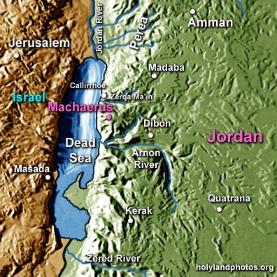
- Map <www.holylandphotos.org>
- Panoramic views: <www.wikimedia.org>; <www.atlastours.net>
- [Areal view] <www.bible-architecture.info>
- Areal view <www.netours.com>
This category currently contains no pages or media.